A standard borehole log tells you what's at one point, but Perth's subsurface is rarely that predictable. Over the last decade we have seen too many projects—from Alkimos subdivisions to Welshpool warehouses—hit unexpected limestone pinnacles or loose paleochannels that a few metres of drilling completely missed. Seismic tomography, using both refraction and reflection methods, bridges that gap by producing a continuous velocity profile across the entire survey line. When your site sits on the Swan Coastal Plain, where the Guildford Formation can transition from stiff clay to running sand over a short distance, this kind of coverage stops you from gambling with foundation design. We routinely pair it with a targeted CPT programme to calibrate seismic velocities directly against tip resistance and sleeve friction.
A single seismic line can replace a dozen boreholes for mapping bedrock continuity, but only if the velocity model is calibrated to local geology—something the Perth Basin demands every time.
Approach and scope
Site-specific factors
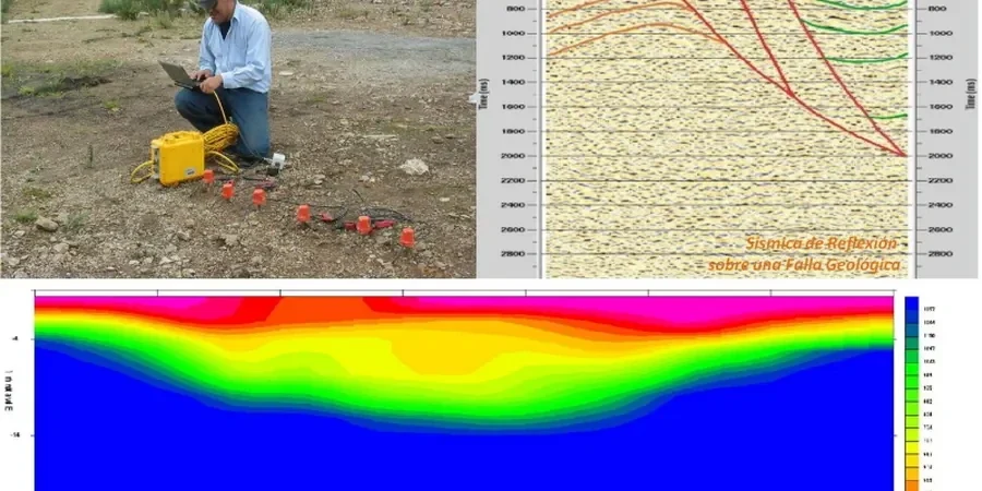
The stark contrast between Perth's dry summers and the winter rains that saturate the superficial formations changes how seismic waves propagate through the near-surface, and it also changes what the ground will do once you open an excavation. Tamala Limestone is notorious for solution cavities and pinnacle weathering along the Cottesloe-to-Yanchep corridor, and missing a karst feature by a few metres can turn a straightforward bulk earthworks package into a grouting or dynamic compaction claim. Our seismic reflection processing specifically targets diffraction hyperbolae that indicate voids, while P-wave velocity drops below 800 m/s flag zones of extremely loose sand or uncontrolled fill. When the survey line crosses a paleochannel—common in the East Perth and Burswood areas—the velocity contrast between the channel fill and the surrounding Spearwood dunes provides an unambiguous target for both refraction interpretation and subsequent ground improvement design.
Relevant standards
AS 1726:2017 (Geotechnical site investigations), AS 4678:2002 (Earth-retaining structures), AS/NZS 1170.0:2002 (Structural design actions), ASTM D5777-18 (Standard Guide for Using the Seismic Refraction Method), ASTM D7128-18 (Standard Guide for Using the Seismic Reflection Method), RIICWD507D (Prepare detailed geotechnical design—Australian resources industry)
Related technical services
Combined Refraction and Reflection Survey
A single spread acquisition that captures both shallow velocity structure and deeper stratigraphic reflectors, ideal for sites where the depth to Cretaceous bedrock or weathered granite must be confirmed across the entire footprint.
SH-Wave Refraction for Soft Ground
Shear-wave surveys in Perth's Bassendean Sands achieve resolution that P-waves cannot, because SH velocities are insensitive to water saturation—critical when the water table sits within 2 m of the surface in winter.
Karst and Void Detection
High-fold reflection profiling with diffraction imaging across Tamala Limestone sites, processed to highlight cavities before they become a problem during piling or basement excavation.
Seismic Velocity Calibration with CPT
Direct correlation of seismic P-wave and S-wave velocities with CPTu data, producing site-specific relationships for liquefaction assessment and FEM soil models.
Typical parameters
Top questions
How deep can seismic tomography see in Perth's sands and limestone?
With a standard 115-metre spread and an accelerated weight drop, we typically achieve 30 to 40 metres of penetration in Bassendean Sand, and 25 to 30 metres in fresh Tamala Limestone. Reflection processing can extend this to 60 metres or more when the target is a strong impedance contrast, such as the sand-over-granite interface common in the Darling Scarp foothills.
How much does a seismic refraction and reflection survey cost for a typical Perth subdivision lot?
For a single-line survey covering 200 to 400 metres with combined P-wave and SH-wave acquisition, the cost generally falls between AU$4,340 and AU$7,560, depending on access conditions, required penetration depth, and the level of processing (tomographic inversion versus simple intercept analysis).
Do you need a water cart or special site preparation before the survey?
In Perth's summer, the dry surface sand can absorb too much seismic energy, so we often recommend light watering along the geophone line the day before acquisition. This is much simpler than drilling pad preparation, and we coordinate directly with your site team to minimise downtime.
Can you differentiate between a limestone pinnacle and a buried boulder in the seismic record?
Yes, but it requires velocity analysis. Fresh limestone pinnacles in the Tamala Limestone typically show P-wave velocities above 2,500 m/s and often produce diffraction patterns in the reflection data. A buried granite boulder in the Bassendean Sand may show a similar velocity but usually lacks the surrounding high-velocity halo that a larger bedrock pinnacle generates. We flag both features in the interpretation report with a recommendation for targeted drilling if the anomaly lies within the structural footprint.