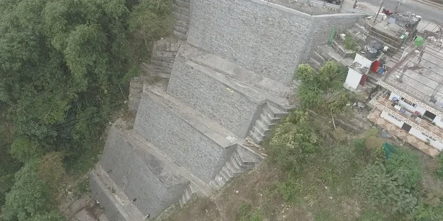
We were called to a residential cut in the western suburbs. Three meters of sand over caprock limestone. The owner had pushed the batter to near-vertical to gain a few square meters of backyard, and the first winter rains had already started slumping the face. What looked like a simple retaining job turned into a full slope stability reassessment because the failure plane was tracking right through the limestone interface. Across Perth, we see this pattern constantly: the Spearwood dune system, the sandy Bassendean soils, the fractured Tamala Limestone along the coast, all creating layered profiles that fail at the boundaries, not within the mass. A desktop review alone is never enough when perched water tables and relic channel deposits can turn a stable 45-degree batter into a progressive failure inside a single wet season. The analysis has to account for suction loss in the sand and the joint persistence in the caprock. We run limit equilibrium models using actual SPT refusal depths and shear strength from triaxial testing because generic parameters from a geological map don't stand up in a DA submission to the City of Perth or a design review under AS 4678.
A 45-degree sand batter stable in February can fail in July. Perth's slope stability is a wet-season problem, not a geometry problem.
Approach and scope
Site-specific factors
Perth sits at just 32 meters elevation on average, but the Darling Scarp rises 250 meters only 25 kilometers inland. That topographic step concentrates failure in two bands: the Scarp itself, where kaolinised granite and laterite produce deep-seated rotational slides after heavy rain, and the coastal limestone cliffs between Trigg and North Fremantle, where undercutting by wave action triggers toppling failures. The 2010 Perth storm event delivered 120 mm in 24 hours to some catchments and triggered dozens of shallow slips across the Scarp, a reminder that the design storm governs the analysis. We model 1-in-100-year rainfall infiltration into the upper sand layer because the antecedent moisture condition changes everything. A slope that factors at 1.8 dry can drop below 1.2 with a perched water table only 1 meter below the surface. For sites within the Swan Coastal Plain, we also check liquefaction-induced lateral spreading as a driver of slope deformation, referencing the Perth Basin seismicity model and NCEER procedures for SPT-based triggering assessment.
Relevant standards
AS 4678:2002 – Earth-retaining structures, AS 1726:2017 – Geotechnical site investigations, AS/NZS 1170.0 & 1170.4 – Structural design actions (seismic), FHWA-NHI-05-123 – Soil slope and landslide stabilization (referenced for Scarp colluvium), NCEER (1997) – Liquefaction resistance of soils (SPT-based, for lateral spread check)
Related technical services
Cut and fill stability assessment
2D limit equilibrium modeling for residential and commercial cuts in Bassendean Sand and Spearwood dunes, with perched water sensitivity and AS 4678 compliance.
Darling Scarp landslide evaluation
Rotational and translational failure analysis in lateritic and colluvial profiles, including rainfall infiltration modeling and debris flow runout estimation where required.
Coastal cliff stability and monitoring
Toppling and wedge failure assessment for Tamala Limestone cliffs, with wave-cut notch surveying, joint persistence mapping, and long-term recession rate analysis.
Typical parameters
Top questions
What Factor of Safety does AS 4678 require for a permanent slope in Perth?
AS 4678:2002 Table 3.1 specifies a minimum static Factor of Safety of 1.5 for permanent slopes where failure would affect structures. For temporary works during construction, 1.3 is generally acceptable. In seismic conditions we apply a pseudo-static coefficient from AS 1170.4 and target 1.1 minimum.
How much does a slope stability analysis cost for a residential cut in Perth?
For a typical single-residence cut in the western suburbs or Scarp foothills, the analysis ranges from AU$2,160 to AU$5,820 depending on whether we need to bring in a drill rig for SPT refusal depths, run triaxial tests on the limestone, or model multiple cross-sections for complex groundwater.
What makes Perth's Tamala Limestone tricky for slope analysis?
The limestone has variable cementation and frequent solution pipes filled with loose sand. The failure plane often follows a weak bedding contact or an infilled joint, not the intact rock. We need site-specific joint surveys and strength testing on the contact material, not just core logs.
Do you include rainfall infiltration in the stability model?
Always. We model a perched water table rising to the surface contact between sand and limestone, using a design infiltration rate from a 1-in-100-year storm event. The pore pressure ratio ru is applied to the upper sand layer, and we run sensitivity cases for 0.5 m, 1.0 m, and 2.0 m perched depths.